
Tiätuvuárkká:Topographic map of Tenerife-en.svg

Tämän PNG-esikatselun koko koskien SVG-tiedostoa: 800 × 592 kovečuággá. Eres resoluutioh: 320 × 237 kovečuággá | 640 × 473 kovečuággá | 1 024 × 757 kovečuággá | 1 280 × 947 kovečuággá | 2 560 × 1 894 kovečuággá | 1 045 × 773 kovečuággá.
Algâalgâlâš tiätuvuárkká (SVG-tiätuvuárkká; nobdum tärkkivuotâ 1 045 × 773 kovečuággá; tiätuvuárhá stuárudah 505 KiB)
Čuákánkiäsu
| Kuvvim |
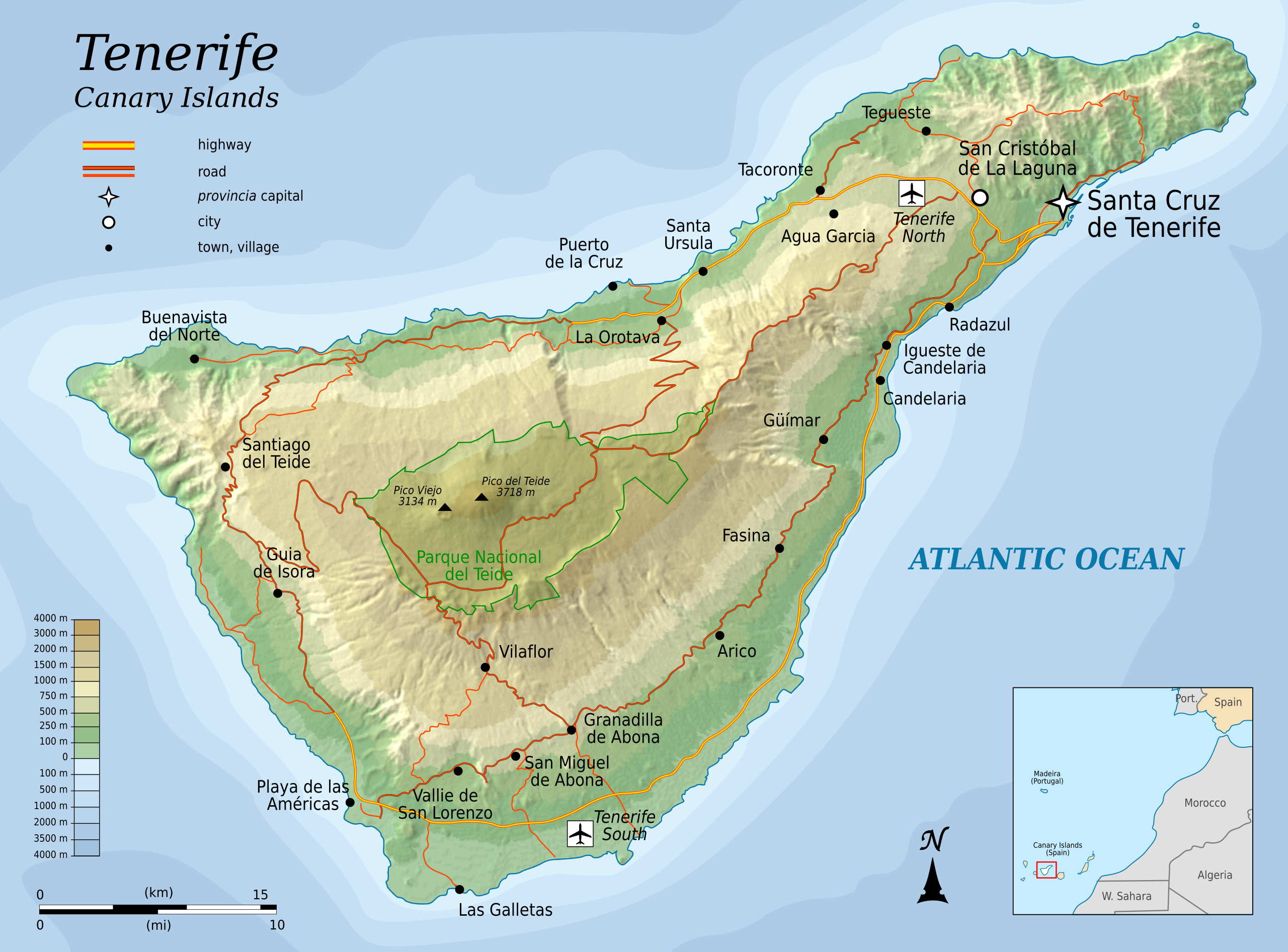
English: Topographic map of Tenerife, an island of the Canary Islands of Spain. |
| Peivim | |
| Käldee |
Self-made in Inkscape.
|
| Rähtee | Oona Räisänen (Mysid) |
| Muut versiot |
|


|
This SVG file contains embedded text that can be translated into your language, using any capable SVG editor, text editor or the SVG Translate tool. For more information see: About translating SVG files. |
Tämä vektorigrafiikkatiedosto luotiin käyttäen apuna ohjelmaa Inkscape .
Liiseens
Minä, tämän teoksen tekijänoikeuksien haltija, julkaisen täten tämän teoksen seuraavilla lisensseillä:
Taat tiätuvuárkká lii lisensistum Creative Commons Noomâ-JyeviSiämmáánáál 3.0 Ij heiviittum -lisenssáin.
- Pyevti:
- jyehiđ – kopijistiđ, levâttiđ já oovdânpyehtiđ pargo
- remiksađ – vaalmâšt muttum pargoid
- Čuovvovaš iävtuin:
- nommâdem – Tun koolgah adeliđ hiäivulávt nommâalmottâs, liiŋkâ lisensân já almottiđ, láá-uv teekstân tohhum nubástusah. Tun uážuh porgâđ taam puoh tohálâš vuovijgijn, mut ij toin naalijn, et oro et lisensadeleijee lii tuárjumin tuu pargo teikâ suu pargo kevttim.
- jyeve siämmáánáál – Jis mutáh teikkâ vuáđudah taan paargon, puávtáh jyehiđ puátusin šoddâm pargo tuše tain teikkâ taan sullâsâš lisenssáin.

|
Puávtáh kopijistiđ, levâttiđ já/teikâ mutteđ taan äššikirje GNU Free Documentation License -liiseens versio 1.2 tai majemui iävtui vyelni, moh láá almostittum Free Software Foundation peeleest; ij kuoskâ muttuuhánnáá soojijd, ij ovdâlohe teevstâid ige kirjelohe teevstâid. Kopio taan lisensist lii finniimist saajeest GNU Free Documentation License. |
Puávtáh valjiđ jieijâd halijdem liiseens.
Tiätuvuárhá historjá
Peeivi colkkâlmáin uáináh, maggaar tiätuvuárkká lâi eidu talle.
| Peivimeeri/Tijme | Miniatyyrkove | Ooláádmudoh | Kevttee | Komment | |
|---|---|---|---|---|---|
| táálááš | 6. porgemáánu 2010 tme 09.25 | | 1 045 × 773 (505 KiB) | Mysid | more roads + north reference |
| 6. porgemáánu 2010 tme 00.45 |  | 1 045 × 773 (466 KiB) | Mysid | add northern airport | |
| 5. porgemáánu 2010 tme 23.30 |  | 1 045 × 773 (463 KiB) | Mysid | fonts | |
| 5. porgemáánu 2010 tme 23.26 |  | 1 045 × 773 (463 KiB) | Mysid | {{Information |Description={{en|1=Topographic map of Tenerife, and island of the Canary Islands of Spain.}} |Source=Self-made in Inkscape. |Author=Mysid |Date=2010-08-05 |Permission= |other_versions= }} {{translation possib |
Tiätuvuárhá kevttim
Taat tiátuvuárkká ij kevttuu mongin siijđost.
Tiätuvuárhá kevttim ubâ systeemist
Čuávuvááh eres wikih kevttih taam tiätuvuárhá.
- Kiävttu saajeest cs.wikipedia.org
- Kiävttu saajeest en.wikipedia.org
- Kiävttu saajeest fi.wikipedia.org
- Kiävttu saajeest fr.wikipedia.org
- Kiävttu saajeest hr.wikipedia.org
- Kiävttu saajeest hu.wikipedia.org
- Kiävttu saajeest ko.wikipedia.org
- Kiävttu saajeest mr.wikipedia.org
- Kiävttu saajeest nl.wikipedia.org
- Kiävttu saajeest pnb.wikipedia.org
- Kiävttu saajeest ru.wikipedia.org
- Kiävttu saajeest sl.wikipedia.org
- Kiävttu saajeest tr.wikipedia.org
- Kiävttu saajeest zh.wikipedia.org