
Tiätuvuárkká:Mt Vesuvius 79 AD eruption-la.svg

Tämän PNG-esikatselun koko koskien SVG-tiedostoa: 800 × 480 kovečuággá. Eres resoluutioh: 320 × 192 kovečuággá | 1 024 × 614 kovečuággá | 1 280 × 768 kovečuággá | 2 560 × 1 536 kovečuággá.
Algâalgâlâš tiätuvuárkká (SVG-tiätuvuárkká; nobdum tärkkivuotâ 800 × 480 kovečuággá; tiätuvuárhá stuárudah 86 KiB)
Čuákánkiäsu
| Kuvvim |
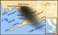
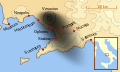
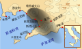
English: A map showing the cities and towns (with their Latin names which were affected by the eruption of Mount Vesuvius in 79 AD ; the general shape of the ash and cinder fall —see w:en:pyroclast— is shown by the dark area to the southeast of Mt Vesuvius.
This map shows modern day coast lines and uses the Mercator projection (although that is not important on a map of this scale). North is, as usual, at the top of the map. Español: El mapa muestra las ciudades y los poblados (con sus nombres en latín) que fueron afectados por la erupción del Vesubio del año 79 d.C. ; las cenizas y los residuos de la erupción volcánica —consultar Piroclasto (tefra)— cayeron al sureste del Monte Vesubio, donde está indicado por la zona oscurecida. |
| Peivim | |
| Käldee | Uámi pargo |
| Rähtee | MapMaster |
References
This map is intended to show the general distribution of (airborne) ash punice, and other particles. I built the map from descriptions of the event as well as these maps:
- Luongo, Giuseppe; Perrotta, Annamaria; Scarpati, Claudio;De Carolis, Ernesto;Patricelli, Giovanni;Ciarallo, Annamaria (2003) "Impact of the AD 79 explosive eruption on Pompeii" in Journal of Volcanology and Geothermal Research v126 pp. 169-200.
- This map.
- Image:Pompeya, el Vesuvio y su alcance.jpg
Other versions
[]
-
 English
 -
 français
 -
 Latina
 -
 Nederlands
 -
 português
 -
 македонски
 -
 русский
 -
 中文
中文 -
 עברית
עברית


|
This SVG file contains embedded text that can be translated into your language, using any capable SVG editor, text editor or the SVG Translate tool. For more information see: About translating SVG files. |
Liiseens
Minä, tämän teoksen tekijänoikeuksien haltija, julkaisen täten tämän teoksen seuraavilla lisensseillä:

|
Puávtáh kopijistiđ, levâttiđ já/teikâ mutteđ taan äššikirje GNU Free Documentation License -liiseens versio 1.2 tai majemui iävtui vyelni, moh láá almostittum Free Software Foundation peeleest; ij kuoskâ muttuuhánnáá soojijd, ij ovdâlohe teevstâid ige kirjelohe teevstâid. Kopio taan lisensist lii finniimist saajeest GNU Free Documentation License. |
Tämä tiedosto on lisensoitu Creative Commons Nimeä-JaaSamoin 3.0 Ei sovitettu, 2.5 Yleinen, 2.0 Yleinen ja 1.0 Yleinen -lisensseillä.
- Pyevti:
- jyehiđ – kopijistiđ, levâttiđ já oovdânpyehtiđ pargo
- remiksađ – vaalmâšt muttum pargoid
- Čuovvovaš iävtuin:
- nommâdem – Tun koolgah adeliđ hiäivulávt nommâalmottâs, liiŋkâ lisensân já almottiđ, láá-uv teekstân tohhum nubástusah. Tun uážuh porgâđ taam puoh tohálâš vuovijgijn, mut ij toin naalijn, et oro et lisensadeleijee lii tuárjumin tuu pargo teikâ suu pargo kevttim.
- jyeve siämmáánáál – Jis mutáh teikkâ vuáđudah taan paargon, puávtáh jyehiđ puátusin šoddâm pargo tuše tain teikkâ taan sullâsâš lisenssáin.
Puávtáh valjiđ jieijâd halijdem liiseens.
Tiätuvuárhá historjá
Peeivi colkkâlmáin uáináh, maggaar tiätuvuárkká lâi eidu talle.
| Peivimeeri/Tijme | Miniatyyrkove | Ooláádmudoh | Kevttee | Komment | |
|---|---|---|---|---|---|
| táálááš | 6. cuáŋuimáánu 2018 tme 11.00 | | 800 × 480 (86 KiB) | -donald- | K changed to km |
| 29. skammâmáánu 2014 tme 01.04 |  | 800 × 480 (88 KiB) | Ras67 | frame removed | |
| 19. roovvâdmáánu 2007 tme 03.17 |  | 659 × 396 (113 KiB) | MapMaster | slight modification | |
| 16. roovvâdmáánu 2007 tme 01.35 |  | 659 × 396 (113 KiB) | MapMaster | slight image fix-up | |
| 15. roovvâdmáánu 2007 tme 20.52 |  | 652 × 396 (113 KiB) | MapMaster | == Summary == {{Information |Description=A map showing the cities and towns affected by the eruption of Mount Vesuvius in 79 AD. The general shape of the ash and cinder fall (see w:en:pyroclast) is shown by the dark area to the southeast of Mt Vesuvi |
Tiätuvuárhá kevttim
Čuávuvâš sijđo kiävttá taam tiätuvuárhá:
Tiätuvuárhá kevttim ubâ systeemist
Čuávuvááh eres wikih kevttih taam tiätuvuárhá.
- Kiävttu saajeest af.wikipedia.org
- Kiävttu saajeest bg.wikipedia.org
- Kiävttu saajeest br.wikipedia.org
- Kiävttu saajeest ca.wikipedia.org
- Kiävttu saajeest cs.wikipedia.org
- Kiävttu saajeest da.wikipedia.org
- Kiävttu saajeest de.wikipedia.org
- Kiävttu saajeest de.wikivoyage.org
- Kiävttu saajeest en.wikipedia.org
- Kiävttu saajeest es.wikipedia.org
- Kiävttu saajeest et.wikipedia.org
- Kiävttu saajeest fi.wikipedia.org
- Kiävttu saajeest fr.wikipedia.org
- Kiävttu saajeest fur.wikipedia.org
Čääiti lase taan tiätuvuárhá vuáhádâhvijđosii kiävtu.