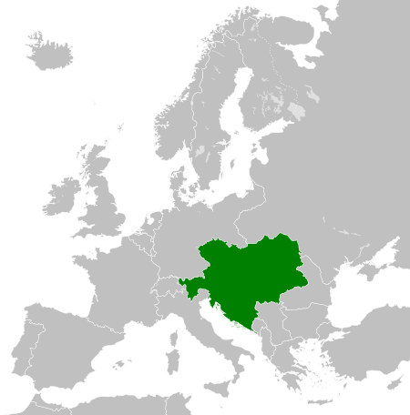
Tiätuvuárkká:Austro-Hungarian Monarchy (1914).svg

Algâalgâlâš tiätuvuárkká (SVG-tiätuvuárkká; nobdum tärkkivuotâ 450 × 456 kovečuággá; tiätuvuárhá stuárudah 456 KiB)
Taat tiätuvuárkká lii juohhum saajeest Wikimedia Commonsist já eres projekteh sättih kevttiđ tom. Tiäđuh tiätuvuárhá kuvvimsiijđost uáinojeh vyellin.
The map is false, Silesia the region in the southern Poland was never polish. The green map should also cover the Silesian land. Prove (do see the coat of arms, there you can see our coat of arms of all Silesians the black eagle with a silver gorget on his chest. Do not lie about our history!!!
Čuákánkiäsu
Koveteevstah
Kohteet, joita tässä tiedostossa esitetään
esittää suomâkielâ
tekijänoikeuden tila suomâkielâ
tekijänoikeuden suojaama suomâkielâ
Creative Commons Attribution-ShareAlike 2.0 Generic eŋgâlâskielâ
Creative Commons Attribution-ShareAlike 1.0 Generic eŋgâlâskielâ
Creative Commons Nimeä-JaaSamoin 2.5 Yleinen suomâkielâ
8. njuhčâmáánu 2012
lataajan oma työ suomâkielâ
MIME-tyyppi suomâkielâ
image/svg+xml
tarkistussumma suomâkielâ
c1ede94fd55b212ad20f67a6c5bb64fc20941ab6
data size eŋgâlâskielâ
466 571 tavu
456 piksel
450 piksel
Tiätuvuárhá historjá
Peeivi colkkâlmáin uáináh, maggaar tiätuvuárkká lâi eidu talle.
| Peivimeeri/Tijme | Miniatyyrkove | Ooláádmudoh | Kevttee | Komment | |
|---|---|---|---|---|---|
| táálááš | 25. syeinimáánu 2013 tme 20.34 |  | 450 × 456 (456 KiB) | Alphathon | Removed Dutch polders (weren't completed until the mid 20th century) |
| 8. njuhčâmáánu 2012 tme 15.39 |  | 450 × 456 (441 KiB) | TRAJAN 117 | {{Information |Description ={{en|1=The Austro-Hungarian Monarchy in 1914.}} |Source ={{own}} {{AttribSVG|German Empire 1914.svg|Alphathon}} |Author =25px '''TRAJAN 117'''... |
Tiätuvuárhá kevttim
Čuávuvâš sijđo kiävttá taam tiätuvuárhá:
Tiätuvuárhá kevttim ubâ systeemist
Čuávuvááh eres wikih kevttih taam tiätuvuárhá.
- Kiävttu saajeest ab.wikipedia.org
- Kiävttu saajeest af.wikipedia.org
- Kiävttu saajeest af.wiktionary.org
- Kiävttu saajeest als.wikipedia.org
- Kiävttu saajeest am.wikipedia.org
- Kiävttu saajeest ang.wikipedia.org
- Kiävttu saajeest an.wikipedia.org
- Kiävttu saajeest ar.wikipedia.org
- Kiävttu saajeest azb.wikipedia.org
- Kiävttu saajeest az.wikipedia.org
- Kiävttu saajeest bar.wikipedia.org
- Kiävttu saajeest ba.wikipedia.org
- Kiävttu saajeest be-tarask.wikipedia.org
- Kiävttu saajeest be.wikipedia.org
- Kiävttu saajeest bg.wikipedia.org
- Kiävttu saajeest bn.wikipedia.org
- Kiävttu saajeest bs.wikipedia.org
- Kiävttu saajeest bxr.wikipedia.org
- Kiävttu saajeest ce.wikipedia.org
- Kiävttu saajeest crh.wikipedia.org
- Kiävttu saajeest cs.wikipedia.org
- Rakousko-Uhersko
- Halič
- Uhersko
- Rakouské Slezsko
- České království
- Šablona:Infobox - zaniklý stát
- Tyrolské hrabství
- Šablona:Infobox - zaniklý stát/doc
- Rakouské arcivévodství
- Moravské markrabství
- Království chorvatsko-slavonské
- Gorice a Gradiška
- Korunní země
- Štýrské vévodství
- Rakouské přímoří
- Kraňské vévodství
- Markrabství Istrie
- Šablona:Korunní země Rakouska-Uherska
- Sedmihradské velkoknížectví
- Wikipedista:Suzukitaro/temp1
- Dalmatské království
- Salcburské vévodství
- Bukovinské vévodství
- Korutanské vévodství
- Rakousko-uherská okupace Bosny a Hercegoviny
- Haličsko-vladiměřské království
- Portál:Rakousko-Uhersko
Čääiti lase taan tiätuvuárhá vuáhádâhvijđosii kiävtu.
Metadata
Taat tiätuvuárkká sisana ovdâmerkkân kovelohhee, digikamera teikâ kovekieđâvuššâmohjelm lasettem lasetiäđuid. Puoh tiäđuh iä innig velttidhánnáá västid tuotâvuođâ, jis kove lii hämmejum ton algâalgâlii rähtim maŋa.
| Lyhyt otsikko | Countries of Europe |
|---|---|
| Kove nommâ | A blank Map of Europe. Every country has an id which is its ISO-3166-1-ALPHA2 code in lower case.
Members of the EU have a class="eu", countries in europe (which I found turkey to be but russia not) have a class="europe".
Certain countries are further subdivided the United Kingdom has gb-gbn for Great Britain and gb-nir for Northern Ireland. Russia is divided into ru-kgd for the Kaliningrad Oblast and ru-main for the Main body of Russia. There is the additional grouping #xb for the "British Islands" (the UK with its Crown Dependencies - Jersey, Guernsey and the Isle of Man)

Contributors.
Original Image: (http://commons.wikimedia.org/wiki/Image:Europe_countries.svg) Júlio Reis (http://commons.wikimedia.org/wiki/User:Tintazul).
Recolouring and tagging with country codes: Marian "maix" Sigler (http://commons.wikimedia.org/wiki/User:Maix)
Improved geographical features: http://commons.wikimedia.org/wiki/User:W!B:
Updated to reflect dissolution of Serbia & Montenegro: http://commons.wikimedia.org/wiki/User:Zirland
Updated to include British Crown Dependencies as seperate entities and regroup them as "British Islands", with some simplifications to the XML and CSS: James Hardy (http://commons.wikimedia.org/wiki/User:MrWeeble)
Released under CreativeCommons Attribution ShareAlike (http://creativecommons.org/licenses/by-sa/2.5/). |
| Kobdodâh | 450 |
| Alodâh | 456 |


